| |
Sightseeing
tours and walks on the Gran Sasso
Below there is a series of itineraries for
excursions to the Gran Sasso d'Italia. Include
detailed map.
The Parco Nazionale del Gran Sasso and Monti
della Laga comprises 11 districts, 6 of which
affect the territory of the Gran Sasso (Strada
Maestra, Valle Siciliana, Alte Vette, Great
Abbeys, of Terre Baronia, Tirino Valley).
These routes are
proposed by the park on the site
www.gransassolagapark.it
Are broken down by district:
District
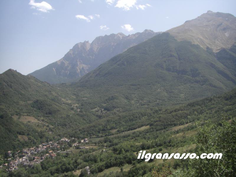
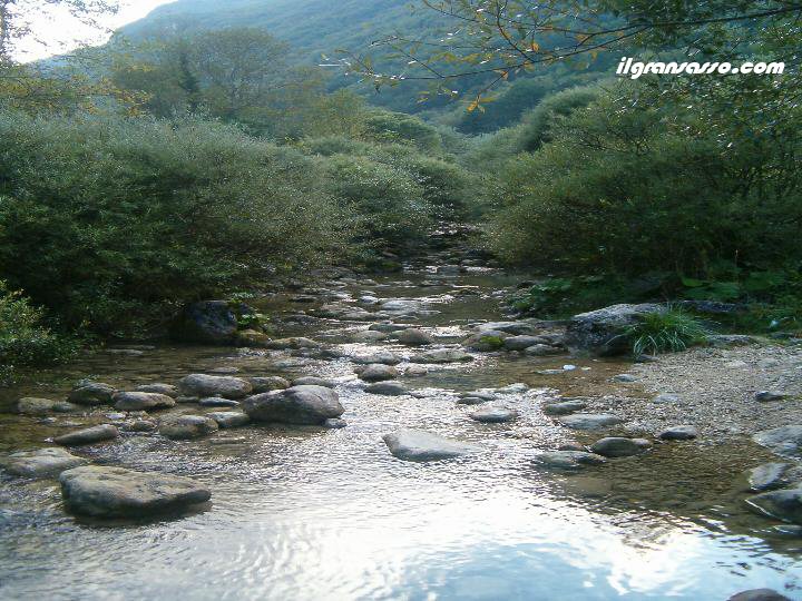
STRADA MAESTRA
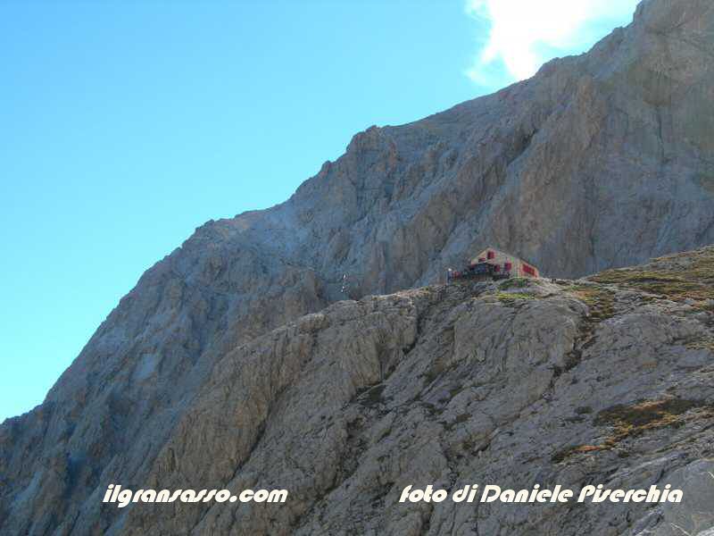
Up: : Franchetti
refuge
Down: Campotosto
Lake
One of the oldest
dell'Appennino along the winding valley
that separates the Gran Sasso Laga.
Excavated in the millennia by the waters
of Vomano, the gap falls from Passo delle
Capannelle to the hills of Montorio, and
the trail was for two thousand years after
one of the most important of the
Appennino. In the eighties the opening of
the Gran Sasso tunnel brought the silence
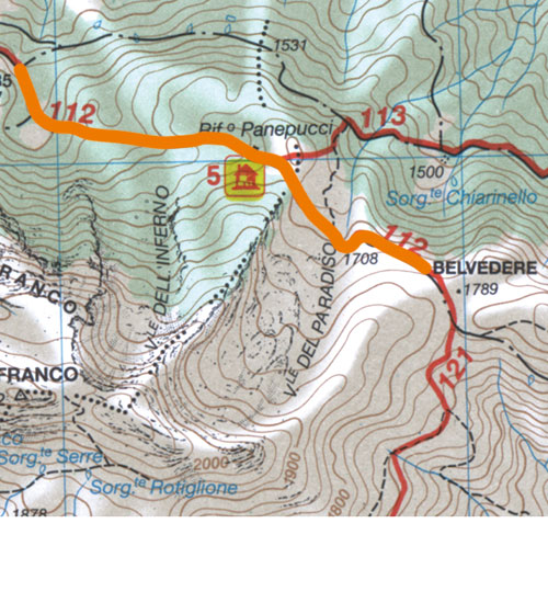
in these places, but gave a serious blow
to the area. Twenty years after the park
was put to work to bring the visitors in
this beautiful area in the heart of the
protected area.
The list of actions carried out or planned
include a restaurant, three guesthouses,
some museums and eighteen thematic areas
to visit. Many villages of the two sides
of the valley are places of great
interest. To the north, at the foot of
Laga, are Cortino with his Abetina,
Crognaleto with the church of Our Lady of
the Tibia, Cesacastina from which rises to
Fosso dell'Acero (or hundred waterfalls),
the small Senaria that between three and
seventeenth century was indeed an ally of
Venice and plan Vomano from which you
climb a Piano and Wind of the remains of a
fortress italica.
From the Gran Sasso can be reached rather
Nerito, Fano Adriano and Pietracamela,
base for climbing the two Horns, which
houses a fascinating old town dominated by
rocky towers. Where the valley widens
Montorio stands on the hills to Vomano
that interesting monuments such as the
church of San Rocco, built starting in
1527.
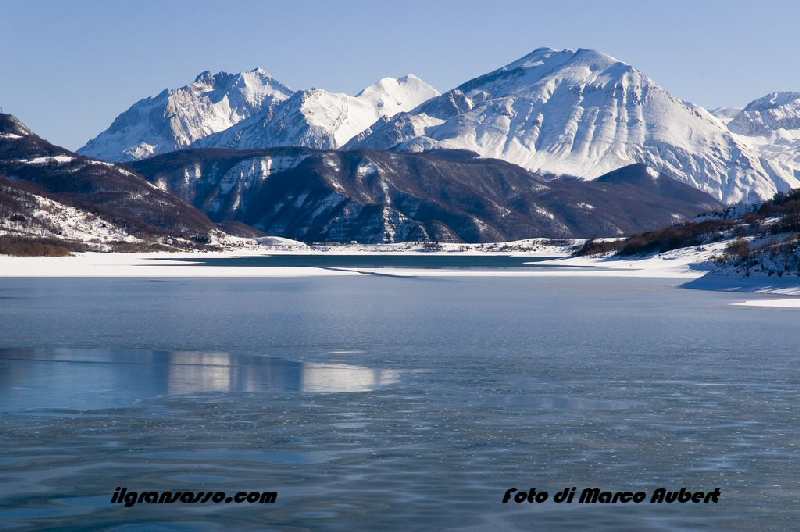
Who loves nature must not overlook the
lake Campotosto at 1313 meters, which took
place at the end of the thirties of an
expanse of marshes and bogs. Magnificent
view on the Laga and Gran Sasso, the basin
is flanked by the countries of Campotosto
- the highest in the City Park, rebuilt
after the earthquake of 1703 - and
Mascioni. In summer the lake is popular
with fans of windsurfing and canoeing. For
most of you are watching the water hen,
the coot, the ferruginous duck, and
osprey. In spring and summer give the
performance of dances of crested grebe
courtship.
The scope and variety of the district
Teacher of the road means that those who
choose to walk between rooms, atmosphere
and level of commitment very different.
Short walks to scenic, such as those from
the Monte Campotosto Cardito or Prati di
Tivo to Alta Cima, alongside classic walks
in the green as excursions Maona Valley
and along the Fosso dell'Acero (or Valley
of the Hundred Waterfalls).
Longer routes and demanding toward the
peaks of Monte Corvo, of Mount Gorzano and
Big Horn, which with its 2912 meters is
the "roof" of the chain and the Gran Sasso
Park. There are difficulties, however,
once the loose snow of winter, rising
dall'Arapietra toward the valley of
Cornacchie, the Franchetti refuge and
Calderone. Dolomitic wall appearance and
the southernmost glacier of Europe make up
the most bell'itinerario mountain of the
protected area.
Itinerario n° 29: Da Campotosto al Monte
Cardito
- Dislivello: 220 metri |
Tempo di salita: 1 ora |
Tempo di discesa: 1.30 ore
| Difficoltà: E
- Itinerario non segnato | Da
aprile a novembre
- Mappa
dell'itinerario
Itinerario n° 30: Da Campotosto al Monte
di Mezzo
- Dislivello: 800 metri |
Tempo di salita: 3 ore |
Tempo di discesa: da 1.30 a 2.15
ore | Difficoltà: E
- Itinerario parzialmente segnato
(bianco-rosso) | Da
giugno a ottobre
- Mappa
dell'itinerario
Itinerario n° 31: Dal Passo delle
Capannelle al Rifugio Panepucci
Alessandri
- Dislivello: 270 metri | Tempo
di salita: 0.45 ore | Tempo
di discesa: 0.30 ore | Difficoltà:
T
- Itinerario parzialmente segnato
(bianco-rosso) | Da
maggio a ottobre
- Mappa
dell'itinerario
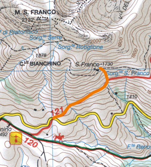
Itinerario n° 32: Dal Passo delle
Capannelle al Monte San Franco
- Dislivello: 700 metri |
Tempo di salita: 2.15 ore
| Tempo di discesa: 1.30 ore
| Difficoltà: E
- Itinerario parzialmente segnato
(bianco-rosso) | Da
giugno a ottobre
- Mappa
dell'itinerario
Itinerario n° 33: Nella Valle del
Chiarino
- Dislivello: 430 metri | Tempo
di salita: 1.30 ore | Tempo
di discesa: 1.15 ore | Difficoltà:
T/E
- Itinerario segnato (giallo-rosso)
| Da maggio a ottobre
- Mappa
dell'itinerario
Itinerario n° 34: Dalla Valle del
Chiarino a Monte Corvo
- Dislivello: 1130 metri | Tempo
di salita: 3.45 ore | Tempo
di discesa: 2.30 ore | Difficoltà:
E (EE nel tratto finale)
- Itinerario segnato (bianco-rosso)
| Da giugno a ottobre
- Mappa
dell'itinerario
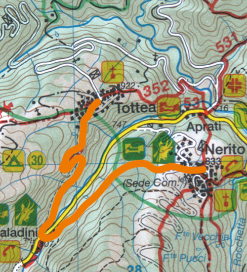
Itinerario n° 35: Da Nerito a Paladini e
Tottea
- Dislivello: 150 metri | Tempo
complessivo: 2.30 ore | Difficoltà:
T/E
- Itinerario segnato (bianco-rosso)
| Da aprile a novembre
- Mappa
dell'itinerario
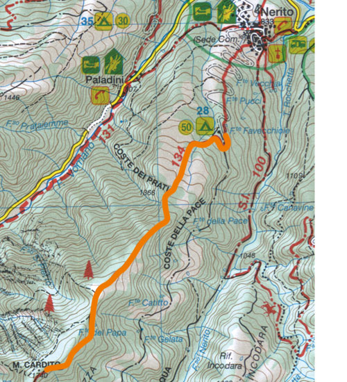
Itinerario n° 36: Da Nerito al Monte
Cardito
- Dislivello: 640 metri |
Tempo di salita: 2.15 ore
| Tempo di discesa: 1.30 ore
| Difficoltà: E
- Itinerario parzialmente segnato (blu)
| Da maggio a novembre
- Mappa
dell'itinerario
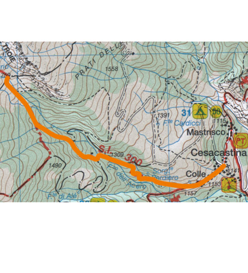
Itinerario n° 37: Da Cesacastina alla
Valle delle Cento Cascate
- Dislivello: 620 metri |
Tempo di salita: 2.15 ore
| Tempo di discesa: 1.30 ore
| Difficoltà: E
- Itinerario parzialmente segnato
(bianco-rosso) | Da
maggio a ottobre
- Mappa
dell'itinerario
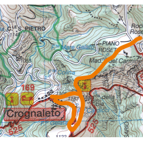
Itinerario n° 38: Da Crognaleto alla
Madonna della Tibia
- Dislivello: 200 metri | Tempo
complessivo: 2.15 ore | Difficoltà:
E
- Itinerario segnato (bianco-rosso)
| Da aprile a novembre
- Mappa
dell'itinerario
Itinerario n° 39: Da Piano Vomano a
Colle del Vento
- Dislivello: 150 metri |
Tempo complessivo: 1.45 ore
| Difficoltà: T/E
- Itinerario segnato (bianco-rosso)
| Da aprile a novembre
- Mappa
dell'itinerario
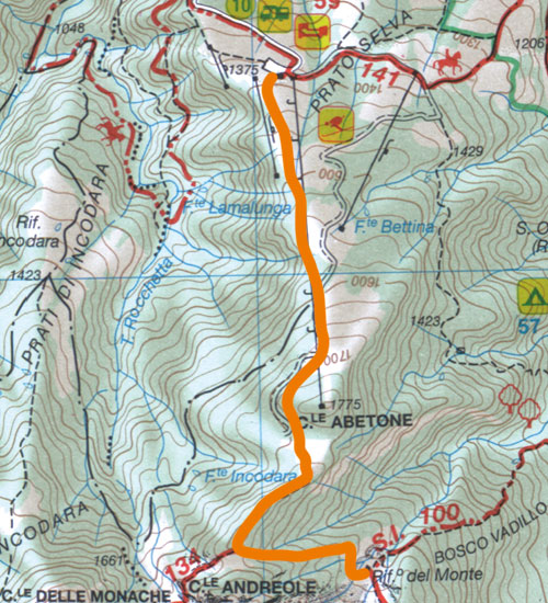
Itinerario n° 40: Da Prato Selva al
Rifugio del Monte
- Dislivello: 530 metri |
Tempo di salita: 1.45 ore
| Tempo di discesa: 1.30 ore
| Difficoltà: E
- Itinerario segnato (bianco-rosso)
| Da maggio a ottobre
- Mappa
dell'itinerario
Itinerario n° 41: Da Pietracamela alla
Val Maone
- Dislivello: 930 metri | Tempo
di salita: 3.15 ore | Tempo
di discesa: 2.30 ore | Difficoltà:
E
- Itinerario segnato (bianco-rosso)
| Da giugno a ottobre
- Mappa
dell'itinerario
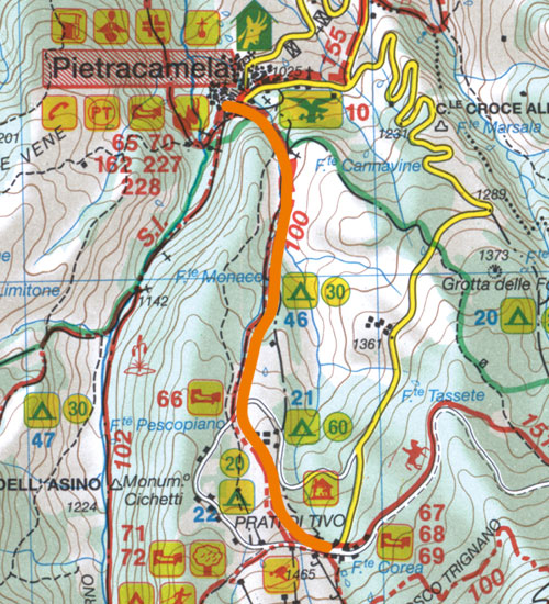
Itinerario n° 42: Da Pietracamela a
Prati di Tivo
- Dislivello: 430 metri | Tempo
di salita: 1.15 ore | Tempo
di discesa: 1 ora | Difficoltà:
E
- Itinerario segnato (bianco-rosso)
| Da maggio a novembre
- Mappa
dell'itinerario
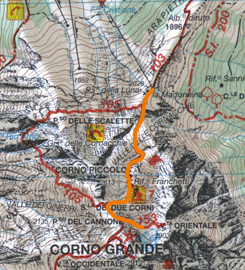
Itinerario n° 43: Dai Prati di Tivo al
rifugio Franchetti
- Dislivello: 680 metri |
Tempo di salita: 1.45 ore
| Tempo di discesa: 1.15 ore
| Difficoltà: E
- Itinerario segnato (bianco-rosso)
| Da luglio a settembre
- Mappa
dell'itinerario
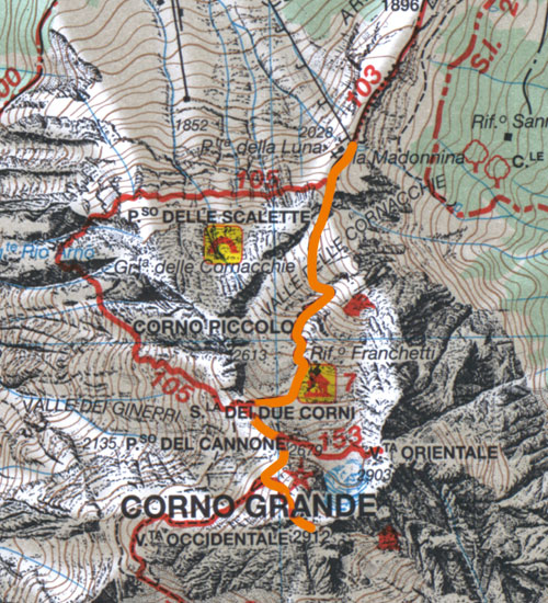
Itinerario n° 44: Dai Prati di Tivo al
Corno Grande
- Dislivello: 910 metri |
Tempo di salita: 2.45 ore
| Tempo di discesa: 2 ore
| Difficoltà: E
- Itinerario segnato (bianco-rosso)
| Da luglio a settembre
- Mappa
dell'itinerario
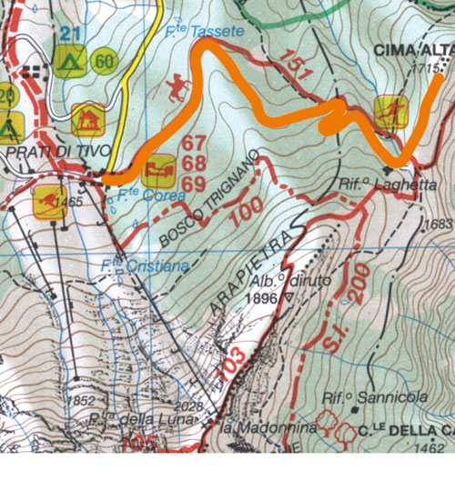
Itinerario n° 45: Dai Prati di Tivo al
Piano del Laghetto
- Dislivello: da 180 a 220 metri |
Tempo complessivo: da 1 a 1.15
ore | Difficoltà: T
- Itinerario parzialmente segnato
(bianco-rosso) | Da
maggio a novembre
- Mappa
dell'itinerario
|
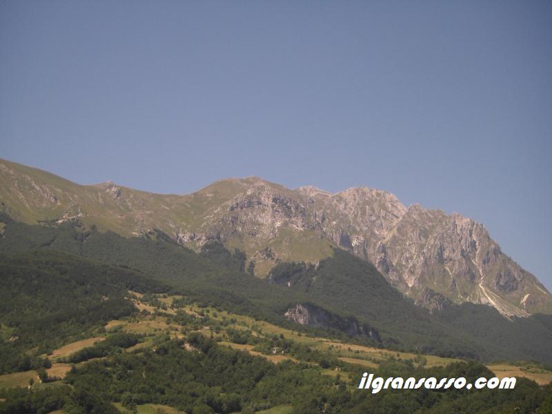
District
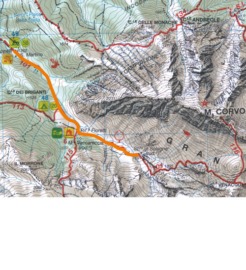
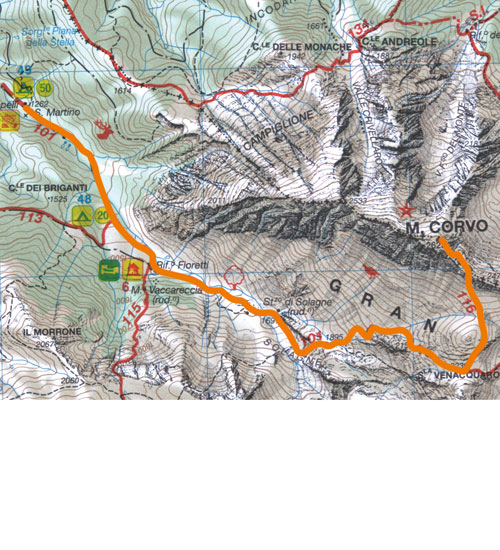
ALTE VETTE
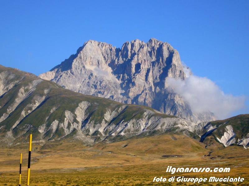
The heart of the
Gran Sasso is made of ropes and walls. The
Corno Grande and the surrounding peaks
offer to those who observe and to whom the
salt atmosphere and mountain landscapes.
Arranged a horseshoe around the small
glacier Calderone - Single dell'Appennino
and southern Europe - the four peaks of
Corno Grande (the highest is the Western,
which reaches 2912 meters) are the highest
in the Park and the chain connecting the
Strait of Messina to Italy.
To the west, over the Val Maona, alongside
their Pizzo d'Intermesoli, Monte Corvo and
Pizzo Cefalonia. The elegance of form and
solidity of the rock means that the peak
is preferred by climbers instead Horn
Piccolo, a turreted castle calcareous
joins the Big Horn from the north, and
faces with its smooth plaques to Prati di
Tivo and Pietracamela. Contribute to
create a mountain refuges (the most
inviting is the Franchetti, in the Valley
of Cornacchie) el'afflusso from all over
Europe to walkers and climbers.
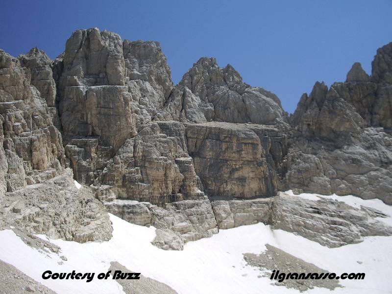
But the nature of the peaks is not just
about rocks. On stony ground, and in
extreme weather conditions, the edelweiss
flower dell'Appennino the Androsace
Matilde, the adonide curved, the
sassifraga del Gran Sasso, the génépi
dell'Appennino and Potentilla in the
Dolomites. Among the animals, in addition
to the Alpine Chough, which accompany the
hikers on the peaks, you can see the
golden eagle, the SORDONI, the coturnice
el'arvicola snow. Lord of these peaks is,
however, the Apennine chamois, hunted to
extinction until nell'Ottocento and
reintroduced since 1992. Today, the
chamois of the Gran Sasso are more than
two hundred and can be more easily spot.
At the foot of the slope of the massif
aquilano the village of Assergi,
surrounded by medieval walls, preserves
the Romanesque church of Santa Maria
Assunta and San Franco, decorated with
frescoes, and the convent of San Francesco
which houses the park. Not far from the
country, the Male Grotto is home to an
enchanting underground lake and returned
to archaeologists a prehistoric
settlement. Easy walks lead to the Valle
del Vasto and its shrines, and scenic
grassy hillocks of Mount Stab.
The heights of elegance and comfort of
access of the area mean that, since the,
paths of this person are the most popular
of the Gran Sasso. Even today, in the
beautiful summer days, to 2912 meters of
the Big Horn climbs a long procession of
walkers. As in other areas of the
protected ìalpineî, however, you must
carefully choose its route.
If the path which leads to Campo Pericoli
is accessible to all, the climb to Corno
Grande, the Cima Giovanni Paolo II, and
frequented Pizzo Cefalonia include steep
and exposed sections, and require mountain
experience and sure footing. In winter,
these trips are reserved for mountaineers.
The steep snow languages that resist long
the field may be un'insidia until July.
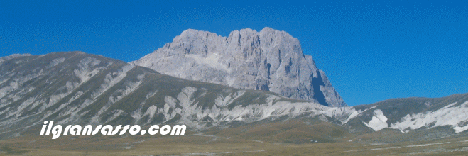
Up: Corno Grande
Down: Calderone
glacier and central peak of Corno Grande
Itinerario n° 46: Dal Colle della Croce
allacqua San Franco
- Dislivello: 260 metri | Tempo
di salita: 0.45 ore | Tempo
di discesa: 0.30 ore | Difficoltà:
T
- Itinerario parzialmente segnato
(cartelli) | Da aprile a
novembre
- Mappa
dell'itinerario
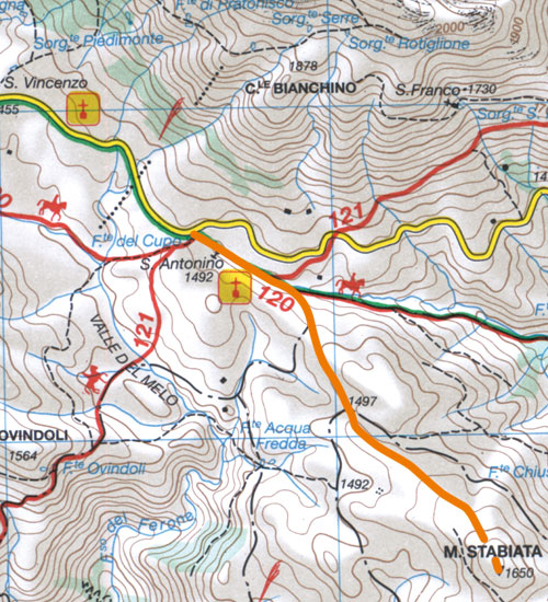
Itinerario n° 47: Dal Passo delle
Capannelle al Monte Stabiata
- Dislivello: 220 metri |
Tempo di salita: 1 ora |
Tempo di discesa: 0.45 ore
| Difficoltà: T
- Itinerario non segnato | Da
aprile a novembre
- Mappa
dell'itinerario
Itinerario n° 48: Dalla Valle del Vasto
al Piano di Camarda
- Dislivello: 950 metri |
Tempo di salita: 2.45 ore
| Tempo di discesa: 1.30 ore
| Difficoltà: E
- Itinerario parzialmente segnato
(giallo-rosso) | Da
maggio a ottobre
- Mappa
dell'itinerario
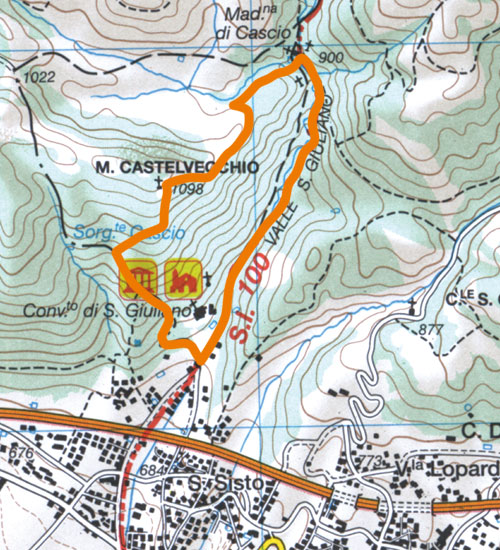
Itinerario n° 49: La Madonna Fore e il
Monte Castelvecchio
- Dislivello: 370 metri | Tempo
di salita: 1.15 ore | Tempo
di discesa: 0.45 ore
- Itinerario parzialmente segnato
(bianco-rosso) | Tutto
l'anno
- Mappa
dell'itinerario
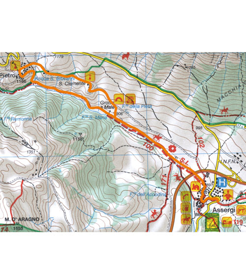
Itinerario n° 50: Da Assergi alla Valle
del Vasto
- Dislivello: 150 metri |
Tempo di andata: da 1.15 ore a 2
ore | Tempo di ritorno:
da 1.15 ore a 2 ore | Difficoltà:
T
- Itinerario parzialmente segnato
(bianco-rosso) | Tutto
l'anno
- Mappa
dell'itinerario
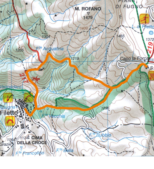
Itinerario n° 51: Da Filetto alle
Abbazie di San Cristante
- Dislivello: 400 metri |
Tempo di andata: 1.45 ore
| Tempo di ritorno: 1.15 ore
| Difficoltà: E
- Itinerario parzialmente segnato
(bianco-rosso, cartelli) | Tutto
l'anno
- Mappa
dell'itinerario
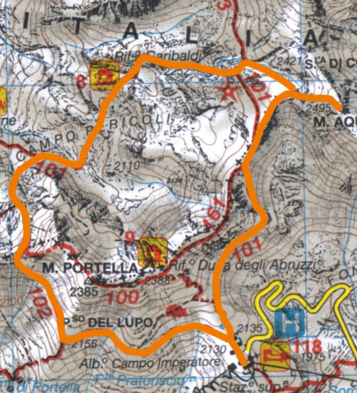
Itinerario n° 52: Dall'albergo di Campo
Imperatore al Monte Aquila
- Dislivello: 400 metri | Tempo
di andata: 2.30 ore | Tempo
di ritorno: 1.15 ore | Difficoltà:
E
- Itinerario segnato (bianco-rosso)
| Da luglio a ottobre
- Mappa
dell'itinerario
Itinerario n° 53: Dall'albergo di Campo
Imperatore al Pizzo Cefalone
- Dislivello: 480 metri |
Tempo di salita: 1.45 ore
| Tempo di discesa: 1.15 ore
| Difficoltà: E
- Itinerario segnato (bianco-rosso n. 1,
sentiero italia e 1a) | Da
giugno a ottobre
- Mappa
dell'itinerario
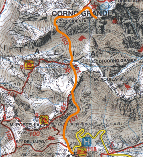
Itinerario n° 54: Dall'albergo di Campo
Imperatore al Corno Grande
- Dislivello: 920 metri |
Tempo di salita: 3 ore |
Tempo di discesa: 2.15 ore
- Itinerario segnato (bianco-rosso n. 3 e
3a) | Da luglio a
settembre
- Mappa
dell'itinerario
|
|
|
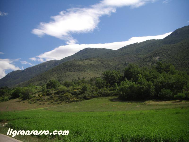
District
VALLE SICILIANA
Other Italian hills
are the most famous of these, few are as
spectacular. Rich in villages and hamlets
and churches as the most celebrated
countryside of Tuscany and Umbria, Sicily
is the Valley a few steps from Teramo and
from the sea, and is easily accessible,
thanks to the Gran Sasso Tunnel, from
L'Aquila and Rome.
To make routine crossings from the hills
and Mavone Fiumetto, however, are the
mountains that form their backdrop.
Dominates the landscape Paretone, the
limestone wall that plunges to
milleseicento meter drop from the peak of
the Corno Grande Eastern. In a clear day
you can see the butterfly, the yellow
overhang created by a mammoth landslide in
1897, and the four huge pillars that give
the streets of mountaineers climbing
harder. To the right of Paretone against
the sky, the towers appear in the Horn
Piccolo. On the left, beyond the woods of
Mount Brancastello and Mount pren, gets up
the wall north of the shirt, but still the
lowest of the wildest Paretone.
Faced with the monuments of the kind that
go up for ever erected by man. A toxic,
the ancient capital of the valley, are the
finest medieval churches of Santa Maria
Assunta and Sant'Antonio Abate. Isola del
Gran Sasso retains considerable fortified
village and parish of St. Maximus. The
state 491, which winds towards the coast,
leading to the church of San Giovanni in
Insulam (XII-XIII century) and continue
towards Ronzano of Santa Maria, which
houses one of the cycles of frescoes
oldest dell'Abruzzo.
Between Island and Colledara, the Shrine
of St. Gabriel of Our Lady of Sorrows is
the most popular of Abruzzo. The great
hall was inaugurated in 1985 by Pope John
Paul II, can accommodate ten thousand
people. The goal of art should not miss in
this area has been Castelli, country
pottery, where many corporations are
continuing even today this ancient
tradition. Born in the Middle Ages, the
art of ceramics castellana had his most
fruitful period between the XV and XVII
century. Today, around the country,
deserve a visit the Museum of Ceramics in
the Franciscan convent of Santa Maria of
Constantinople and the church of San
Donato, with its ceiling composed of 800
tiles, which Carlo Levi described the
church Ila Chapel the Sistine maiolicaî.
Well known to those traveling between
Teramo and L'Aquila (or Roma), Sicil.iana
Valley is not well-known paths
enthusiasts. E 'un error. A dense network
of easy paths, largely identified and
marked by the Italian Alpine Club and the
Park, the links between their countries
and offers pleasant walks through fields
and woods, with a view of great mountains.
Along these routes deserve a break
villages, shrines, walls of ancient
castles.
A little further up the paths to the Fund
or the Salsa at the foot of Paretone allow
even those who do not practice climbing
close to admire some of the most
spectacular natural architecture of the
Gran Sasso. The wild nature and man, here,
seem to be the hand.
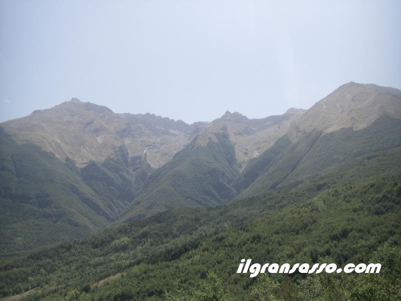
Up : The north
wall of Mount Camicia, more left the
"wolf's tooth"
Down : The nort
wall of Mounts Camicia and Brancastello
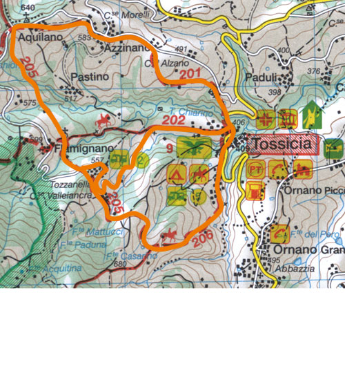
Itinerario n° 55: L'anello delle
frazioni di Tossicia
- Dislivello: da 230 a 250 metri |
Tempo complessivo: da 2 a 2.15
ore | Difficoltà: T
- Itinerario parzialmente segnato
(bianco-rosso) | Tutto
l'anno
- Mappa
dell'itinerario
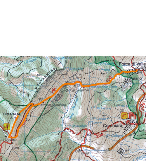
Itinerario n° 56: Da Forca di Valle a
Pianalunga
- Dislivello: da 410 a 970 metri |
Tempo di salita: da 1.15 a 3 ore
| Tempo di discesa: da 0.45 a
2 ore | Difficoltà: E
- Itinerario segnato (bianco-rosso)
| Da maggio a ottobre
- Mappa
dell'itinerario
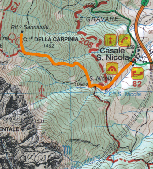
Itinerario n° 57: Da Casale San Nicola
all'Eremo e al rifugio San Nicola
- Dislivello: 800 metri | Tempo
di salita: 2.15 ore | Tempo
di discesa: 1.30 ore | Difficoltà:
E
- Itinerario segnato (bianco-rosso)
- Mappa
dell'itinerario
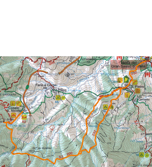
Itinerario n° 58: Da Casale San Nicola a
San Pietro
- Dislivello: in salita 280 metri
| Dislivello: in discesa 380
metri | Tempo
complessivo: da 4.15 a 4.45 ore |
Difficoltà: E
- Itinerario segnato (bianco-rosso)
| Da aprile a novembre
- Mappa
dell'itinerario
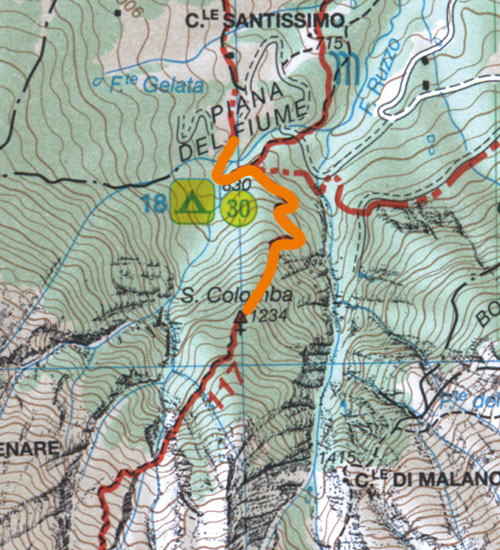
Itinerario n° 59: Dal piano del fiume
all'Eremo di Santa Colomba
- Dislivello: da 380 a 400 metri
| Tempo di salita: da 1 a 1.30
ore | Tempo di discesa:
da 0.45 a 1 ora | Difficoltà:
E
- Itinerario segnato (bianco-rosso)
| Da maggio a novembre
- Mappa
dell'itinerario
Itinerario n° 60: Dal lago di Pagliara
al Castello di Pagliara
- Dislivello: 130 metri |
Tempo complessivo: 1.15 ore
| Difficoltà: E
- Itinerario parzialmente segnato
(cartelli) | Tutto
l'anno
- Mappa
dell'itinerario
Itinerario n° 61: Da Castelli al fondo
della Salsa
- Dislivello: 400 metri |
Tempo di salita: 1.15 ore
| Tempo di discesa: 0.45 ore
| Difficoltà: E
- Itinerario segnato (bianco-rosso)
| Da maggio a ottobre
- Mappa
dell'itinerario
|
|
|
District
TERRE DELLA BARONIA
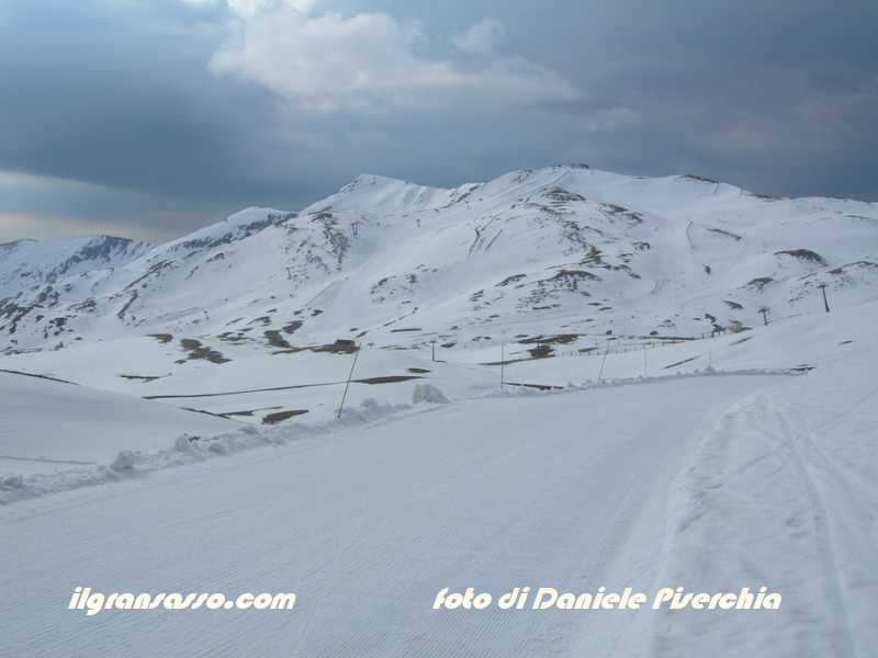
Up: Campo
Imperatore
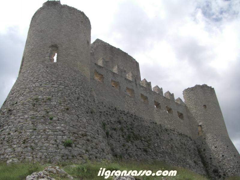
Down: Rocca
Calascio castle
Campo Imperatore
could well be Tibet : remember the
boundless plains of Phare Dzong, 4200
meters, on the road between India and
Lhasa. " The words of Fosco Maraini,
orientalist and mountaineer who visited
Florence for the first time on Gran Sasso
in the late thirties, into the best way to
the vastness of Campo Imperatore, the
largest plateau dell'Appennino, which
stretches to the foot of the peaks most of
the eastern Gran Sasso.
On the plateau, as indicated in the past
or Campradore Field Radduro have grazed
for centuries, in the summer, hundreds of
thousands of sheep. And 'the value of
these boundless grasslands explain why
other famous Florentines - the Medici
family, which based its wealth on the
processing of wool - have acquired land in
1579 and feuds at the plateau margin
south. In Santo Stefano di Sessanio, one
of the most perfect medieval villages of
the Park, the emblem of the Medici
Florence still welcomes visitors.
Were the local lords, the barons of
Carapelle Calvisio, instead to give his
name to the district that includes the
Park and the Campo Imperatore bare slopes
that rise to the plateau from conca
Aquilana and the Plains of Navelli. Arise
in this area, as well as Santo Stefano di
Sessanio, fortified fences (recipes) of
Barisciano, Castel del Monte,
Castelvecchio Calvisio and San Pio delle
Camere.
Castel del Monte, dell'altopiano door for
those coming from the Plains of Navelli,
home to some beautiful churches and the
"cultural circuit", a museum dedicated to
the history and traditional crafts.
Calascio, overlooking the Plains of
Navelli Sirente and preserves the parish
of San Nicola and the convent of Santa
Maria delle Grazie. Midway between the two
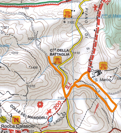
countries, the Plains of San Marco
separates the center of Italian fortified
Colle della Battaglia from a Medieval
village unearthed recently.
Symbol of this area of the park, as well
as Campo Imperatore, however Calascio
Rocca, one of the most photographed
castles in Italy. Founded around Mille,
belonged to Acclozemora, the Piccolomini
and the Medici and was enriched at the end
of the sixteenth century with the four
cylindrical towers that make it
recognizable for tens of miles away. The
village at the foot of the castle is being
restored. The gaze, then, it joined the
Big Horn and Majella.
Often also a horse trail, mountain bike or
ski from the bottom (the links in the
eastern part of Campo Imperatore are among
the most spectacular in Italy), this
sector of the Gran Sasso offers hiking
routes and length of commitment varies,
but united by the solemn and sometimes
frankly severe.
Whether you choose the short walks in the
Valley of Hell, to the ruins of the
Cistercian grancia of Santa Maria in Monte
Rocca or Calascio or the steep and
strenuous Sgambati towards solitary and
rocky peaks of Mount Camicia and Mount
pren, pastures and stony Campradore to
offer hikers a unmistakable.
Itinerario n° 62: Da Barisciano al Piano
delle Locce e a Santa Maria Carboni
- Dislivello: 570 metri |
Tempo di andata: 3 ore |
Tempo di ritorno: 2.45 ore
| Difficoltà: E
- Itinerario segnato (bianco-rosso)
| Da aprile a novembre
- Mappa
dell'itinerario
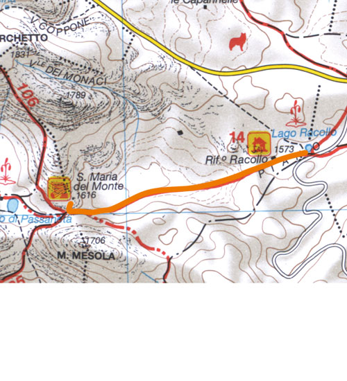
Itinerario n° 63: Dal Lago Racollo a
Santa Maria del Monte
- Dislivello: da 90 a 190 metri
| Tempo complessivo: da 1.30 a
2 ore | Difficoltà: T
- Itinerario segnato (bianco-rosso)
| Da maggio a ottobre
- Mappa
dell'itinerario
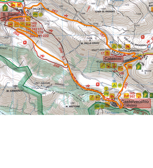
Itinerario n° 64: L'anello di Santo
Stefano di Sessanio, Calascio e
Castelvecchio Calvisio
- Dislivello: 590 metri | Tempo
complessivo: 3.30 ore | Difficoltà:
E
- Itinerario segnato (bianco-rosso)
| Da aprile a novembre
- Mappa
dell'itinerario
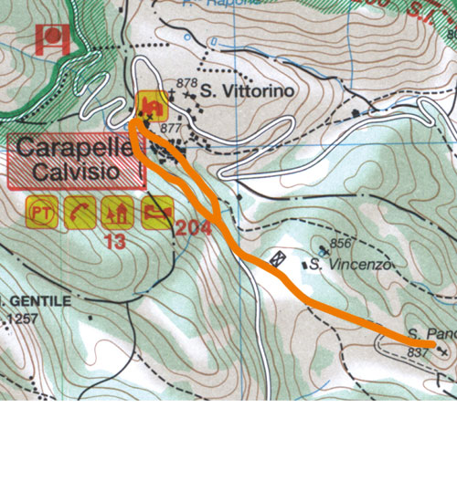
Itinerario n° 65: Da Carapelle Calvisio
al Santuario di San Pancrazio
- Dislivello: 250 metri |
Tempo di andata: 1 ora |
Tempo di ritorno: 1 ora |
Difficoltà: T
- Itinerario parzialmente segnato
(cartelli) | Da marzo a
novembre
- Mappa
dell'itinerario
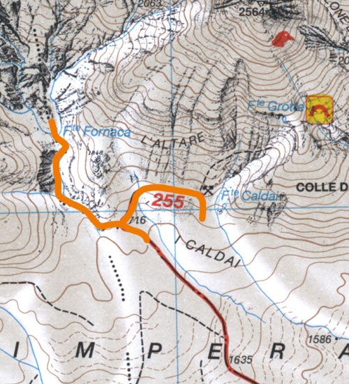
Itinerario n° 66: Il Vallone della
Fornaca e il "Masso Aragonese"
- Dislivello: 120 metri |
Tempo complessivo: 1.30 ore
| Difficoltà: E
- Itinerario parzialmente segnato
(giallo-rosso) | Da
maggio a ottobre
- Mappa
dell'itinerario
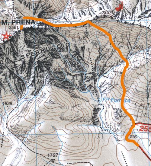
Itinerario n° 67: Dal Vallone della
Fornaca al Monte Prena
- Dislivello: 880 metri |
Tempo di salita: 3 ore |
Tempo di discesa: 2.15 ore
| Difficoltà: E/EE
- Itinerario segnato (giallo-rosso)
| Da giugno a ottobre
- Mappa
dell'itinerario
Itinerario n° 68: Da Fonte Vetica al
Monte Tremoggia
- Dislivello: 980 metri |
Tempo di salita: 2.45 ore
| Tempo di discesa: 1.30 ore
| Difficoltà: E
- Itinerario segnato (bianco-rosso)
| Da giugno a ottobre
- Mappa
dell'itinerario
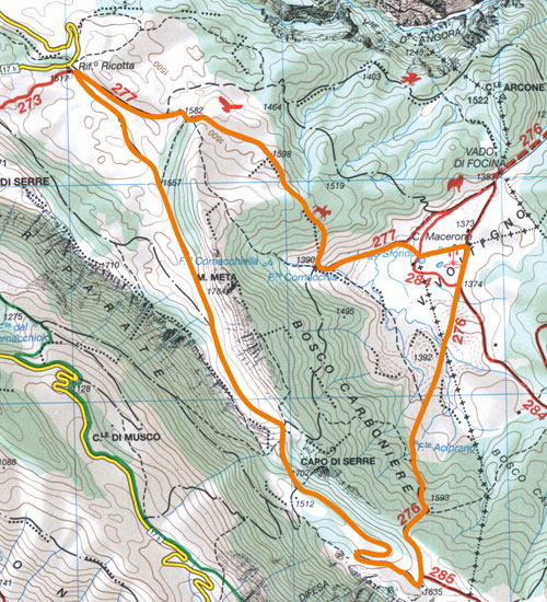
Itinerario n° 69: Dal rifugio Ricotta al
Voltigno
- Dislivello: 400 metri |
Tempo complessivo: 3.45 ore
| Difficoltà: E
- Itinerario parzialmente segnato
(bianco-rosso) | Da
maggio a novembre
- Mappa
dell'itinerario
Itinerario n° 70: Dal Piano San Marco al
Colle della Battaglia
- Dislivello: 120 metri |
Tempo complessivo: 2 ore
| Difficoltà: T/E
- Itinerario non segnato | Da
maggio a ottobre
- Mappa
dell'itinerario
|
|
|
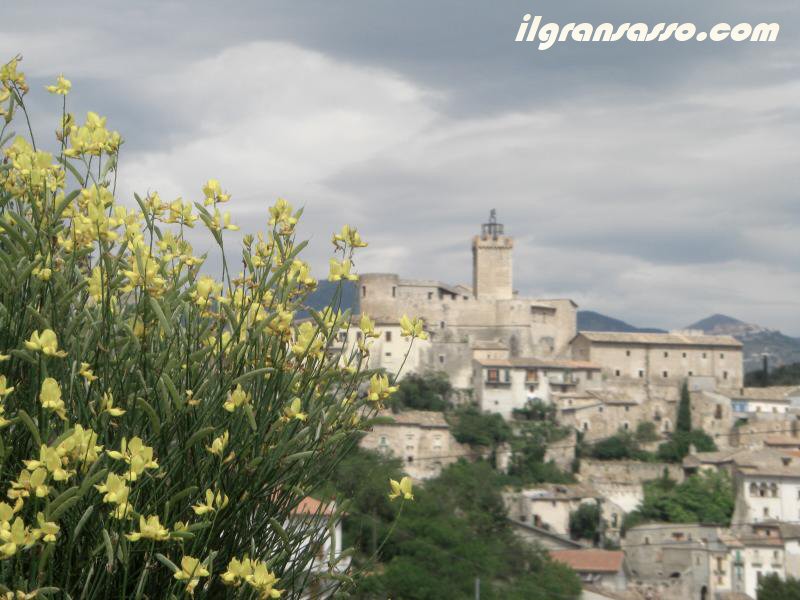
District
GRANDI ABBAZIE
Between Gran Sasso
and the Majella, a ravine perpetually
beaten by the wind puts in communication
the interior highlands of Abruzzo with the
Adriatic coast. Crossings of the paths
Italici and then the Via Tiburtina Roman
Peoples of the Gorge are now traveled by
rail, by state and highway linking Rome
and the Tyrrhenian coast in Pescara.
Here the park that protects the Monti
della Laga and Gran Sasso with a border
that protects the Majella, the "mother
mountain" in the tradition of Abruzzo.
Lifting his eyes toward the sky, the rocks
of Monte Picca and Mount Roccatagliata of
north west and the south east Morrone
reported that the wildlife is near.
Leaving behind the Gorge, a short but
winding road leads to gems like the nature
of the Voltigno plateau surrounded by
dense beech forests, the canyons of the
Valley of Angri the waterfall and the
Golden Calf.
The story is an important reminder to
these places. If the Majella, "Lebanon of
us Abruzzi" in Ignazio Silone wrote, is
home to overtime tied at Hermitages Fra
'Pietro da Morrone, later Pope Celestine
V, and other people of faith, on the
valley floor and in the south-eastern Gran
Sasso arise the most important abbeys of
Abruzzo.
San Clemente a Casauria, the most famous
of all, thrill visitors with its elegant
bas-reliefs of the three portals and the
porch, with the quiet elegance of the
Interior, with the wealth dell'ambone
carved by Brother James of Peoples and the
candlestick paschal candle made in the
thirteenth century by a Roman column in
granite. Founded nell'871, the abbey was
destroyed by the Saracens in 920 and by
the Normans in 1076 and 1097, and was
rebuilt between 1176 and 1182. Shortly
after there was drafted the Chronicon
casauriense, a document crucial to know
the history of the Middle Ages.
We must move away from the valley floor to
reach the Abbey of San Bartolomeo della
Nora, founded in 962 and rebuilt in the
XII and XIII, which has a severe portal
lintel, a simple and charming interior and
a beautiful ceiling tiles. Only a few
ruins are surrounded by brambles, close to
Villa Celiera, instead reported the
presence of Santa Maria Casanova, the
first Cistercian abbey of Abruzzo.
For hikers, the slope of the Gran Sasso
Pescara offers itineraries very different
from them, often pleasant in spring and
autumn advanced, and often hot in the
middle of summer, making it possible to
appreciate areas of great fascination. The
major peaks are far from these places.
The references for those who walk in this
area of the massif, is the plateau of
Voltigno pastures, the wild canyons of the
Valley of Angri, the pinnacles of Merletti
bizarre and wild Gravone funnel of the
canyon that affect the north - east of
Monte Alb. The wildlife area in the
territory of Rigopiano can without any
difficulty sighting the deer, reintroduced
in this part of the mass in 1992.
Up: Tavo river in
the Angri valley in Farindola
Down : Mount
Camicia from Farindola, near Chamois
oasis
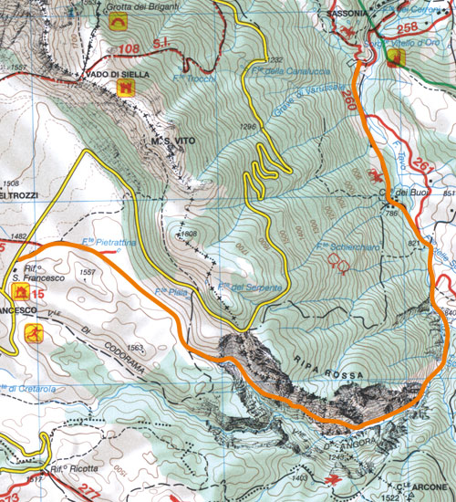
Itinerario n° 71: L'area faunistica del
camoscio e la cascata del Vitello
d'Oro
- Tempo complessivo: da 0.30 a
2.45 ore | Difficoltà:
T/E
- Itinerario non segnato | Tutto
l'anno
- Mappa
dell'itinerario
Itinerario n° 72: Dal Mortaio d'Angri al
Vallone d'Angri
- Dislivello: da 770 a 800 metri
| Tempo di salita: da 3.30 a 4
ore | Tempo di discesa:
da 3 a 3.30 ore | Difficoltà:
E/EE
- Itinerario segnato (giallo-rosso, n° 21)
| Da aprile a novembre
- Mappa
dell'itinerario
Itinerario n° 73: Da Campo Imperatore al
Vallone d'Angri
- Dislivello: da 770 a 800 metri
| Tempo di salita: da 3.15 a
3.45 ore | Tempo di
discesa: da 2.45 a 3.15 ore | Difficoltà:
E/EE
- Itinerario segnato (bianco-rosso)
| Da maggio a ottobre
- Mappa
dell'itinerario
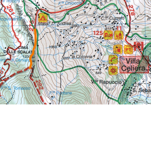
Itinerario n° 74: I merletti di Villa
Celiera e la Cima delle Scalate
- Dislivello: 200 metri | Tempo
complessivo: 1.30 ore | Difficoltà:
E
- Itinerario parzialmente segnato
(bianco-rosso) | Da
maggio a novembre
- Mappa
dell'itinerario
Itinerario n° 75: Sul Piano del Voltigno
- Dislivello: 150 metri |
Tempo complessivo: 2.15 ore
| Difficoltà: T/E
- Itinerario parzialmente segnato
| Da maggio a novembre
- Mappa
dell'itinerario
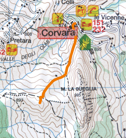
Itinerario n° 76: Da Corvara al Colle
Rotondo
- Dislivello: 360 metri | Tempo
di salita: 1.15 ore | Tempo
di discesa: 1 ora | Difficoltà:
E
- Itinerario non segnato | Tutto
l'anno
- Mappa
dell'itinerario
|
|
|
District
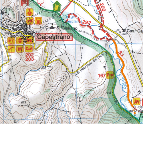
VALLE DEL TIRINO
The waters of the
southern side of Gran Sasso returned to
the light sources in two of the most
beautiful and abundant dell'Abruzzo. The
Tirino among the clearest rivers and
picturesque dell'Appennino, stems from the
spectacular resurgences of Capo d'Acqua e
Presciano, and is heading south east
flanked by extensive reed beds and rare
trees such as willow cinerino.
No need to go so close to water, however,
to discover the charm of this area of the
park. The arid basin of Ofena,
traditionally referred to as "the furnace
of the Abruzzi" hosted by years of
vineyards. The state, which descends from
a Navelli Peoples through the solemn
plains where in 1934 it was found the
statue of the Warrior Capestrano, ancient
symbol of Abruzzo and the entire world
Italic, now exhibited in the National
Archaeological Museum of Chieti.
Monitors the plane's historic center
Capestrano, where are the turreted castle
that belonged to the Piccolomini and the
Medici and the convent and the church of
San Giovanni da Capestrano, from the late
fifteenth century. The limestone walls of
Mount Roccatagliata dominate Bussi sul
Tirino, industrial center which houses an
intact medieval village. A few meters from
which links to the conca Aquilana Peoples
are the ruins of the church of Santa Maria
di Catignano, built shortly after the
Mille as part of the Benedictine abbey,
whose frescoes are preserved in the Museo
Nazionale de L'Aquila.
The most important monument of this area
of the park, however, is the church of San
Pietro ad Oratorium, the only building
come to this day the former founded in 752
by the Lombard king Desiderius, which
houses a beautiful Romanesque portal and
important frescoes of the twelfth century.
Traditionally thin by hikers, the area is
well known to other friends of nature.
Canoeing enthusiasts will often give
appointment on the clear waters of Tirino.
Those who prefer birdwatching can see the
water hen, the porciglione and the
kingfisher, all breeding species which may
occur throughout the year, and Tuffetto
the coots, ducks and herons that stop just
next to Tirino d ' winter.
The pass of Forca di Penne, guarded by a
stern medieval tower, offers a convenient
way of communication between the Abruzzo
aquilano and the hills of Pescara, and
thus the birdwatcher to observe numerous
species of migratory species. The dirt
roads that run alongside the river are
open to tours by bike or on horseback.
Even those who enjoy walking, however, can
find interesting routes in this district
of the park. From the saddle of Forca di
Penne, deserves exploration on foot,
begins the steep trail through a dense
forest that climbs to the summit of Monte
Picca, one of the lesser-known peaks, and
most surprising of the Gran Sasso. Routes
are more comfortable next to Tirino
possible, among the vineyards and the
historic straw Ofena or between the latter
and Villa Saint Lucia degli Abruzzi. Even
the small number of the park offers tours
and surprises.
Up: On the Tirino
river in Bussi sul Tirino
Down: View of
Capestrano
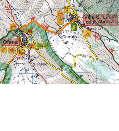
Itinerario n° 77: Da Ofena a Garrufo e a
Villa Santa Lucia
- Dislivello: 280 metri |
Tempo di salita: 1 ora |
Tempo di discesa: 0.45 ore
| Difficoltà: T
- Itinerario non segnato | Tutto
l'anno
- Mappa
dell'itinerario
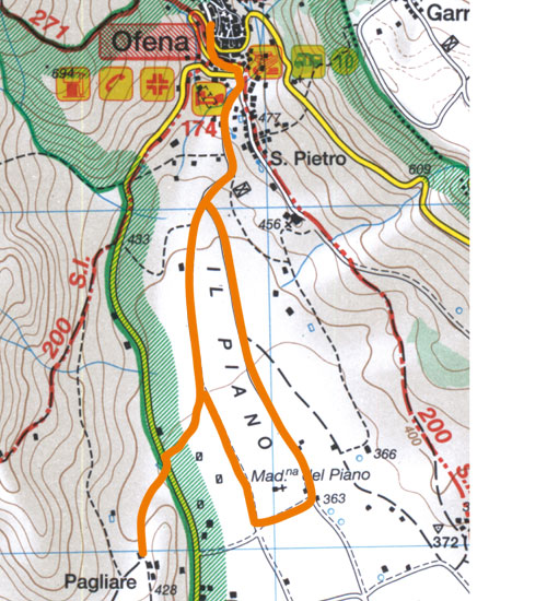
Itinerario n° 78: Da Ofena al Piano e
alle Pagliare di Ofena
- Dislivello: 160 metri |
Tempo complessivo: da 2.30 a 3
ore | Difficoltà: T
- Itinerario non segnato | Tutto
l'anno
- Mappa
dell'itinerario
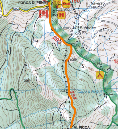
Itinerario n° 79: Da Forca di Penne al
Monte Picca
- Dislivello: 500 metri |
Tempo di salita: da 1.30 a 1.45
ore | Tempo di discesa:
da 1 a 1.15 ore | Difficoltà:
E
- Itinerario non segnato | Da
aprile a novembre
- Mappa
dell'itinerario
Itinerario n° 80: Lungo le anse del
Tirino
- Dislivello: 30 metri |
Tempo complessivo: 2 ore
| Difficoltà: T
- Itinerario non segnato | Tutto
l'anno
- Mappa
dell'itinerario
|
|
|