| |
Territory,
Hydrography,
Flora, Fauna, Hystorical notes, Gran Sasso laboratories
Territory
The Gran
Sasso (or Gran Sasso d'Italia) is the highest
mountain of the Apennines. The Corno Grande is
the highest peak of the mountain (2912 m.).
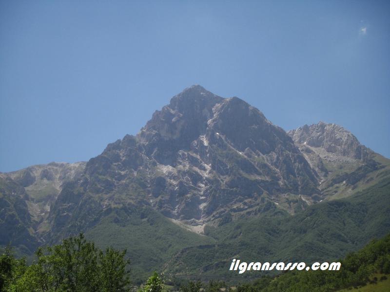
The Corno Grande
Is contained
entirely in the Abruzzo region on the border
between the provinces dell'Aquila, Teramo and
Pescara.
Bordered to the north by the territories of
Pietracamela and Isola del Gran Sasso
d'Italia, to the east with the Glens of
Peoples, is limited to the south from Campo
Imperatore (and over the spurs of Mount
Scindarella, Monte Portella and Pizzo
Cefalonia -- the plain of Assergi), while to
the west-north-west border with the Monti
della Laga and Lake Campotosto.
The Gran Sasso d'Italia is an area protected
by the institution of the Parco Nazionale del
Gran Sasso and Monti della Laga. The Parco
Nazionale del Gran Sasso and Monti della Laga
covers 3 regions (Abruzzo, Marche, Lazio), 5
provinces (L'Aquila, Pescara, Teramo, Ascoli
Piceno, Rieti), 44 municipalities (AQ: Barete,
Barisciano, Cagnano Amiterno, Calascio,
Campotosto, Capestrano, Capitignano, Carapelle
Calvisio, Castel del Monte, Castelvecchio
Calvisio, L'Aquila, Montereale, Ofena,
Pizzoli, Santo Stefano di Sessanio, Villa
Saint Lucia. TE: Arsita, Campli, Castelli
Civitella del Tronto, Cortino , Crognaleto,
Fano Adriano, Isola del Gran Sasso, Montorio
al Vomano, Pietracamela, Rocca Santa Maria,
Torricella Sicura, Tossicia, Valle Castellana.
PE: Brittoli, Bussi sul Tirino, Carpineto
della Nora, a Casauria Castiglione, Civitella
Casanova, Corvara, Farindola, of Montebello
Bertona, Pescosansonesco, Villa Celiera. AP:
Acquasanta Terme, Arquata del Tronto. RI:
Accumoli, Amatrice.
From its most distant points, the Passo delle
Capannelle west and the Glens of Peoples in
the south-east, the Group of Gran Sasso is
about 50 km.
Oriented from northwest to southeast, as the
vast majority of groups and Appennine
preappenninici, has two main sottocatene
parallel: the first, northernmost, extending
from Monte Corvo (2623 m, north-west) to Vado
di Sole (south-east). The sottocatena southern
stretches from Passo delle Capannelle and
Mount St. Franco (2132 m, north-west) to Mount
Head of Serre (1771 m, south-east). Beyond
this central area there is a large area
south-east, the southern spurs, which are
characterized by numerous reliefs lower: Monte
Ruzza (1643 m), Monte Bolz (1904 m), Monte
Camarda (1384 m), Monte cap (1802 m), Monte
Picca (m 1405) and many others, to the Gorges
of Popoli.
The major peaks are in the northern
sottocatena: the Corno Grande, which consists
of three main peaks: the east (2903 m), the
Central (2893 m) and higher, Western (2912 m),
and the Little Horn (m 2655). Between the two
horns are the remains of the Calderone
glacier, the southernmost glacier in Europe.
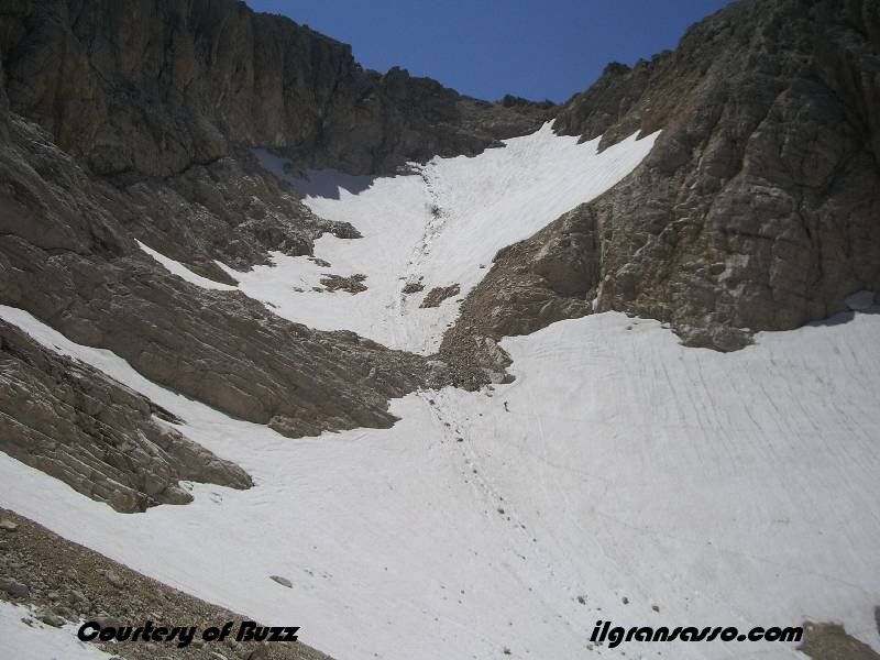
Calderone Glacier
The Gran Sasso is
without doubt the most important landscape
"Alpine" Appennino. In it you can find many
characteristics typical of the Alpine massifs,
such as sharp peaks, deeply carved valleys,
moraines, cirques and valleys shaped by
Quaternary glacial. The north-eastern slopes
with steep rocky walls, all peaks, pinnacles
and deep furrows, on the southern side, behind
massive limestone, we find a series of
degrading upland karst so sweet and varied. In
some of these plans there are lakes of karst
origin, such as that of Barisciano of
Passaneta of Racollo, St. Peter, filet of
Assergi of Lake Sinizzo and Wallpaper. Going
down to south, from Campo Imperatore Paganica
to the intense karstic erosion has resulted in
several caves of different size and depth
(Grotta Male and dell'Oro) and to swallow,
some active, some fossils. Other caves are
also present in the north, around Rigopiano
(Grotta del Lupo and dell'Eremita) and deep,
such as the Bandito, Pozzo di Elisa, and Pozzo
dell'Inferno.
Special consideration should be given to the
Calderone Glacier, located just below the
north slope of Corno Grande at an altitude of
2775 that, with an area of approximately 6
hectares, is the only glacier dell'Appennino
and is the southernmost of Europe. Because of
low winter snow that has characterized the
eighties, there has been a worrying decline of
perennial ice thickness. Continuous monitoring
in which scholars take this precious element
has noted a recovery in recent years, also
testified that he returned to form the lake in
Sofia collection point of the waters of the
thaw. In the summer of 1993 there was a
greater dissolution of snow covering the ice,
causing the surface of moraine debris. The
area of the Gran Sasso is rich in valuable
water that filtered through the limestone
karst of the plans, down to the valley, giving
life to countless resurgent. Among these, the
most notable are the sources of Ruzza, the
Golden Calf, del Rio Arno, Cold Water, the
Brigand of Angri, Water Source and the Santa
Vetica, often picked for civilian use, or
tributaries of streams that in turn feed into
the major rivers in the area. Among them: the
Vomano, rising from the northernmost sector of
the chain, the Fino, the Tavo that arises from
the Valley of Angora, in the east and the west
side in Tirino.
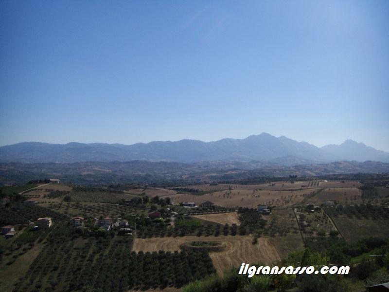
The Gran Sasso chain
from province of Pescara
Hydrography
The Gran Sasso
offers a wide variety 'of lakes and rivers.
Below are cited the main.
.
|
Campotosto Lake
Campotosto lake
is the largest artificial lake of
Abruzzo. It is situated at an altitude
of 1313 m s.l.m. and an area of 1400 ha.
It can be reached by taking the SS. 80
from L'Aquila or the Adriatic coast.
During the glacial lake basin had a form
of a double Y. Once the glacial epoch
has left the bed where flows the Rio
Fucino. With the creation of artificial
lake that is the shape of a V, in
practice the upper part of double Y.
The artificial lake was created in the
thirties-forties by the construction of
three dams, in order to use its waters
for the operation of hydroelectric site
in the valley of Vomano. The flooded
river bed covered the bog that supplied
fuel for local industries. Until the
beginning of 1900 in the bottom of the
lake was extracted peat.
In winter, visitors can admire the lake
completely frozen in the autumn while
you admire the cover of the woods of
colors of the season.
|
|
|
Capo d'Acqua
lake
Here is the most
abundant source that feeds the river
Tirino. The lake is owned 'private.
The invasion comes in the second half of
the'60s to the area a water reserve for
irrigation of surrounding land, is now
also used by Enel to supply a
hydroelectric plant.
It 'always in this area which was found
many years ago the famous Warrior
Warrior Aufinateo Capestrano a witness
of a great necropolis italica located in
the area. Again here, there was one of
the earliest settlements of Mesolithic
abruzzese came to light during work on
the construction of the artificial lake.
Many artefacts found in this zone.
|
|
|
Vomano river
The Vomano can be
said the second of two major rivers
surrounding the Gran Sasso d'Italia, the
Aterno being the first. Matrinus in
antiquity was called by Strabo and Pliny
by Vomanum.
Vomano The river originates in the
province of near Passo delle Capannelle,
about 1200 meters above sea level, on
the north western slopes of Mount St.
Franco.
Flows in the northern part of Abruzzo
and its route of 76 km is almost
completely covered by the province of
Teramo in eclusione a short section in
the province of 'Aquila. Flows into the
Adriatic Sea at Roseto degli Abruzzi.
.
The basin extends over 782 km2 and is
bordered on the left with the basin of
Tordino.
In the top of the bed is dug Vomano
within a groove etched in the Miocene
sandstones intercalated layers of clay,
in the interim by limestone shores and
finally in the last stretch up to
mouth, the bed expands on alluvial
soils. The river collects the
contribution of over thirty large water
bodies and
small.
|
|
|
Tirino river
Beautiful stretch
of water from the Gran Sasso, the
aquifer system of Campo Imperatore.
After a karst of 25 km, out of a valley.
The water flow rate is constant
throughout the year (6000 l / sec) at a
temperature of 11 °, no tributaries, the
waters are always clear. Tirino River is
one of most rivers' cleanest in Europe.
Downstream, feeds three sources, Capo
d'Acqua, Presciano and the small lake
below Capestrano but the largest inflow
is from Capo d'Acqua being the other two
almost firm. The name derives from the
greek "crushed" and means precisely
threefold source, the valley in which
flows are also called Tritan valley or
valley chopped. Bussi is at the left
tributary of the Pescara River.
|
|
|
Tavo river
The river Tavo
born in the foothills east of Gran
Sasso, near Mount Guardiola (1828 m), in
Pietrattina, to 1560 m. E 'along 42 km.
Joins the river up to form the Salt
River.
During the ice ages, all surface water
from the melting of the glaciers of
Campo Imperatore, is channeled into the
ditch and Cretarola
in Vallone D'Angora, and just this
immense quantity of water is responsible
for the formation of these gorges by
towering cliffs. Currently, the surface
transport is almost nil in the gorges,
and occurs mainly by underground
(karst).
After crossing the valley, flowing into
a wider valley, the Valle D'Angri and
mortar locations D'Angri is channeled
into a narrow gorge, called the Mouth of
hell, where the turbines for Tavo
penetrates then lead to a ' other valley
where it forms a spectacular waterfall
28 meters high, the waterfall of the
Golden Calf, the source of the most
important of the southern group of the
Gran Sasso. Note the contrast between
the rocky slopes with little vegetation
or bare and hollow that appears green
trees cresciutivi spontaneously. The
course through the territory of the
National Park is rich with a thriving
riparian vegetation, habitat for a
diversity of animal species. The river
is populated in this section by fario
trout. Among birds, the Blackbird
acquaiolo, the white dancer, the
ballerina yellow, the grass snake from
the neck, the great spotted woodpecker.
|
|
|
Ruzzo river
The river is born
on Monte Prena at 2560mt. Right
tributary of the river Mavone.
|
|
|
Nora river
The river born
on Mount Scarafano(1433 m). Left
tributary of the river Pescara.
Has a length of 28 km.
|
|
|
Sfondo lake
Tiny lake on the
plain of Voltigno.
Characterized by cold even in summer.
The popular belief has it that the
bottom and has not even going to lead
directly to the sea.
|
|
|
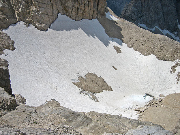
Sofia lake
Lake place at
2678 meters s.l.m. Began to disappear
from the 70's during the construction of
the Gran Sasso tunnel, its extinction
was completed by the end of the 80s. Had
a diameter ranging from 8 meters. and 60
meters and a depth of about 3 meters. It
was fed by melting glaciers that flow
through two or more streams. The water
then into a inghiottitoio which was
blocked by ice in some summers.
Trivia: In 1947 there was a film called
"The Enchanted stone."
Now when its extinction was close, some
local climbers and tried to obstruct the
inghiottitoio with gravel, in vain.
The water of the lake was quite
drinkable. such as (almost) every melt
water.
Source:
http://abruzzomolisenatura.forumfree.net
|
|
|
Rio Arno river
Stems from the
mountain of Intermesoli (2646 m) on the
Gran Sasso (dell'Oro Cave), and has a
total length of 9
Km
Right tributary of the river at Vomano
Fano Adriano at Pietracamela, 30 km.
from Teramo, Poggio Umbricchio turn on
the SS. 80th
|
|
|
Mavone river
The river Mavone
is born in the Gran Sasso (2912 m) and
has a total length of 23 Km
Has the largest tributary to the river
Ruzza.
A turn is a tributary of the river
Vomano right
at St. Augustine. The Mavone which is
the branch of the richest Vomano water
perennial, born in Monte Horn by a named
source who is in a pit of Hell said
Horn, who soon after accepted the ditch
Spoledra and then, at Fano a Corno, the
moat and the San Nicola fosso Vittore,
and then at Isola del Gran Sasso, the
river water rich Ruzza of Fossaceca and
Malepasso. Recently I finally had the
lead Leomogna, from castles and Fiumetto
from Castiglione della Valle.
|
|
Fino river
The river comes up
from the north-east of Mount
Tremoggia at 1200 meters above sea
level, is a classic river Appennine
with trends across the mountain
ridge from which arises. Its length
is 48 km, its catchment area is
approximately 282 sq. km. and a
slope that varies from 3 to 9
percent in the mountain, and from 1
to 3 percent in the lower. Its
catchment area is almost one third
higher than the Tavo. After a
journey of about 25 km, until the
leaves the province of Teramo and
enters into that of Pescara, here
after about 15 km, at
Joint, joins with the river Tavo
giving rise to a river which flows
called Saline little town north of
Montesilvano, bordering Marina di
Città Sant'Angelo.
The river has a winding pattern
that, by setting up between the deep
gorges and valleys, leaving little
room for the flood plain.
|
|
Pietranzoni lake
Small body of water
located in front of the Monte
Brancastello, not far from Corno
Grande to Campo Imperatore.
Enchanting scenery.
|
|
Calascio lake
Artificial lake in
town Calascio.
It must be said that the village of
Calascio regarding the water supply
directly from a source upstream of
the reservation, but when the tank
is full, you spill the water in the
lake and in the case truly abundant
winter snow, the flow of water that
is poured into the lake is truly
impressive.
|
|
Flora
The exposure of the two different
sides of the mountain range, separated by a
line of very high ridge, gave birth to a
different tree crown cover. The northern
side has a good forest integrity in the
presence of extensive well-preserved beech
with beech trees, Aceri, Abeti white and
Betulle.L 'White Fir, Abies Alba, the
Apennines, it is noted in sporadic
appearances on the slopes of Monte Corvo, in
the catchment of Rocchetta and Venaquaro and
higher only on the slopes of Colle Pelato in
toxicity.
The Birch, Birch pendula, is present in the
last few stations around Arsita and Isola
del Gran Sasso. The rate, Taxus baccata, is
present with the majestic specimens of Angri
Vallone, Voltigno. The woods of Chiarino,
Monte S. Franco and the forest Codaro
Campiglione, all located in the north-west
of the massif, are well known examples of
the richness of the tree crown cover of this
side.
Towards the east, however, there are the
Prati di Tivo, molded by glacial Quaternary,
characterized by a discontinuous forest
interspersed with large meadows, on which
grows a very rich flora and varies with
Anemoni, gentian, orchids and Primule. The
valley of the Rio Arno upstream of Prati,
very evocative and full of water, has a good
environmental integrity: here it is easy to
admire the Giglio martagone or Riccio di
Dama and Giglio Rosso, and many small bog
with cotton grass.
Faggeta summarizes the nature of continuity
as they proceed toward the east, stretching
along the slopes of the mountains
Brancastello, book, shirt, Tremoggia, Siella
and San Vito, where the over two thousand
meters vegeta the rare Edelweiss Appenine.
South of Rigopiano open, carved by the river
Tavo, the valley of Angri. Again, the
planting is done by Beech to which accompany
the maple, the Hornbeam, the Pit, in
addition to rate. Continuing southward,
there is the Valley of Angora, with a real
beech forest in the canyon, and the
spectacular karst of Voltigno plan,
consisting of a prairie Nardeti, Nardus
stricta, surrounded by large beech groves.
Several of Peonie bloom, bluebells and
Gentian greater.
But perhaps the most peculiar character of
appearance of the Gran Sasso botanical lies
in the presence of numerous endemics, mostly
above the timberline. Among them we remember
over the Apennine Mountain Star, the Purple
Maiella, the Sassifraga leaf opposite the
Genepì Apennines, the Mattioli, the Adonide
curved and rare and symbolic Androsace
Abruzzo, a small and delicate primulacea
known only for very small areas of
Altomontana Gran Sasso and Maiella.
Remarkable, also, the presence of other rare
species such as yellow and Adonide Limoni
aquilano, whose only stations are aquilano
side of the park.
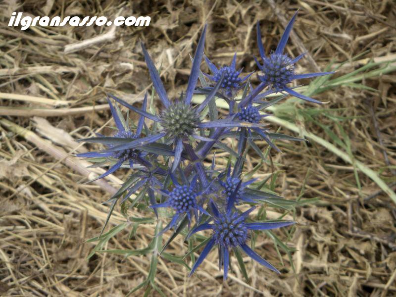
A flower of Appennino
Fauna
The fauna of the Gran Sasso is the
rate, the Faina, the weasel, the fox, the
hare, the polecat, the Scoiattolo south, the
wild cat, the wolf (very rare), chamois
(reintroduced in 1992 to Farindola) , wild
boars, the Istrice and Marten. Particularly
rich is the bird life, represented by more
than 100 species. Very rare birds of prey,
including peregrine falcons and golden
eagles are still present and their nests,
while some species, such as the bearded
vulture, which is the certainty of their
presence at the end of the last century,
have now disappeared. Remaining forest areas
in the nest Astore, the sparrowhawk, and
especially the Poiana. During the spring and
autumn it is easy to see the cuckoo Falco,
the harriers or kestrel Falco. Species such
as the Gracchi and alpine coral can be seen
on the slopes of Corno Grande and Monte Alb.
The Gracchi Reef is on the Gran Sasso nuclei
with numerous and well distributed to ensure
the conservation of the species now in sharp
decline in all the other mountains of Italy
and Europe. More difficult to see are the
Coturnici, the small Wallcreeper and
Fringuello Alpine appearances on major
massiccio.L 'erpetofauna presents rare
species such as dell'Orsini Viper, Vipera
Aspis and the species of the genus Natrix.
Among the amphibians is to report the Rana
graeca, the rarest Italian Anura. There are
also Ululone by yellow belly and Rana
dalmatina, the salamander and the occhiali
Salamandra pezzata.
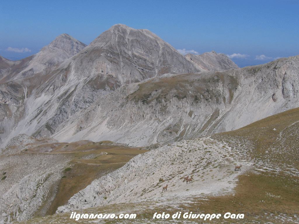
A group of Chamois
on the Gran Sasso
Historical
notes
The whole Appenine about 200 million
years ago was flooded by an ocean. The
approach of the continents, pushing and
corrugated surfaces in a continuous rock for
millions of years, has meant that the
various types of the overlapping layers in
several places, so that about 6 million
years ago, during the desiccation of the
Mediterranean , (known to scholars as the
"salinity crisis") of the Gran Sasso chain
should look like a partially raised in
relation to another post in the north and
identified as "the basin of Laga." So today
we can find a few hundred meters away rocks
very different, in fact once they were at
distances considerably larger. The massive
limestone "and" Triassic dolomite "of the
Big Horn, in fact, come from the bottom of
an area known as" platform ", characterized
by a shallow sea, rich in oxygen that
favored the settlement of organisms such as
foraminifera, molluscs alghe.Da and a
geomorphological point of view, the Gran
Sasso is a mass of sedimentary origin
composed of dolomite, limestone, generally
massive and marls. Origi about 6 million
years ago (Miocene), dell'emersione in the
context of the Apennines, was later stages
of thrust and compression that generated a
series of fractures and drops (Val Maona,
Valle del Venacquaro, Campo Pericoli, Campo
Imperatore). On these, starting with 600,000
(Günz) to about 10,000 (Würm) years ago,
acted the erosive forces of ice ages. These
signs have left particularly evident,
especially on the northern side of the
group: small glacial cirques are
identifiable characteristic, for example, in
the area of Mount St. Franco (the valleys of
hell and heaven), but also in the vicinity
of Mount Eagle and Mount of Scindarella. The
glaciers were bigger natural points of
convergence of these glacial cirques in high
places, for example, the glacier that
occupied Campo Pericoli nourished by
circuses places north of the ridges of the
Big Horn, Mont Eagle, Monte Portella and
Pizzo Cefalonia. In these basins the snow is
compacted and turned into ice, resulting in
Val Maona to Pietracamela, where are still
visible remains date back to the moraine of
the Riss glaciation. Since the successive
glaciations have erased the marks left by
earlier ones, and because of the Riss
glaciation is older than the Würm, rissiana
this moraine is one of the rare evidence
that the valleys of the Gran Sasso have been
occupied by glaciers over and over times
during Neozoico.
In 1573 it was conquered for the first time
the top of the Horn Grande.La expedition was
led by captain Francesco De Marchi. It was
an extraordinary given the time and
equipment available to climbers. The real
exploration of the Gran Sasso mountaineering
began in the late nineteenth century with
the conquest of the different peaks in the
group.
On 19 August 1573 the military engineer
captain Francesco De Marchi climbed by side
dell'Aterno the highest peak of the Gran
Sasso d'Italia (Corno Grande, West Summit).
The companions were the Caesar Milan
Schiaffino and Diomede from L'Aquila, guides
and porters, by Francesco di Domenico di
Assergi and Simon and Giovanpietro Julius.
The description of the then outstanding
business is contained in a manuscript
preserved in the Biblioteca Comunale di
Bologna. Two centuries later, July 30 1794,
the scientist Horace Teramo Delfico reached
the Summit of the Eastern side by the Great
Horn of Isola del Gran Sasso. But the real
exploration of the mountaineering team after
beginning the ascent made by Saint Robert
July 20 1870. On 9 January 1880, and
Corradino Sella Gaudenzio carried the first
winter ascent of Corno Grande, 8 September
1887 Enrico Abbate and guidance of John
Acitelli Assergi climbing Horn Piccolo, in
July 1888 the Ugolini and guidance De Nicola
reached the tops of the mountain and Mount
Crow reservation, August 10 1892 O. Gualerzi
and G. Acitelli the Summit of the Central
Great Horn, making the first rock climbing,
8 February 1893 Abbate, Gualerzi, Gavin
Acitelli and carried the first winter ascent
of Corno Piccolo. Mountaineering guides
without starting the Gran Sasso in 1910 with
the crossing of the three peaks of Corno
Grande, made by the Austrians and Schmidt
Riebeling. Followed immediately climbing the
Sucaini Roman (Sebastiani, Bram,
Chiaraviglio, Berthelet etc..) And, shortly
after the First World War, those of the
Roman and Milanese mountaineers (Jannetta,
Bonacossa etc..) On the most impressive
ridges and walls of the massif. From 1932
onwards is also developed on the Gran Sasso
modern climbing with the intervention of
"Aquilotti of Pietracamela and climbers
Aquilani (Giancola, Sivitilli, Marsilio,
D'Armi and others), as well as
internationally renowned mountaineer
(Bonacossa , Gervasutti, Maraini etc..),
with firms that touch the sixth grade. But
the opening of streets full of difficulties
and extreme winter the conquest of the most
difficult walls belong to the last decades,
because of renewed suca Rome (Council
Alletto, Mario, Cravino etc.). Aquilani and
mountaineers and Marches (A. Bafile,
Calibani, Florio and others), describing the
Gran Sasso mountain mountaineering interest
in every aspect.
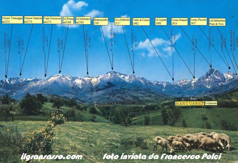
An old postcard of the
Gran Sasso
Gran
Sasso laboratories
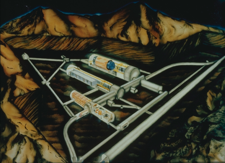
Gran Sasso Laboratories
The Gran Sasso
Laboratories (LNGS) are the largest
underground laboratories in the world, and are
located 1,400 m below the top of the Gran
Sasso massif, near the Gran Sasso tunnel of
the highway A24 Roma-Teramo, which through the
mountains. In addition to the underground
laboratories, the structure also has
laboratories, which have Assergi (AQ), near
the exit from the idea of Assergi.Nati
Antonino Zichichi, construction began in 1982
and were built together motorway tunnel in
Gran Sasso. Five years later there was held
the first experiment. The underground
laboratories contain three "salt" (room A,
room B room C) whose typical dimensions are
100 m long and 20 m wide and 20 m in height.
In addition to the three main halls
underground laboratories consist of some local
service (Guardiole of sorveglienza, toilets,
facilities for filling and pumping of air,
etc..), From the tunnel link (one of which
connects all the three rooms and 'large enough
to allow the passage of large trucks) and some
other small experimental areas where there are
some experiments placement of small geometric
dimensions. In two small auxiliary tunnel,
specially made, he found a place
interferomentro though. Passatti times in some
experiments also used the detectors placed on
top of the mountain above the underground
laboratories and the data recorded were
analyzed in conjunction with or in
anticoincidenza those buried in the
laboratory. Its position in the mountains
makes it possible to reduce significantly the
flux of cosmic rays and allows you to simplify
the detection of particles like the neutrino
or the search for dark matter.
|
|